
Datoteka:Iran 2001 CIA map.jpg

Vidi sliku u punoj veličini (2.036 × 2.037 piksela, veličina datoteke: 1,84 MB, MIME tip: image/jpeg)
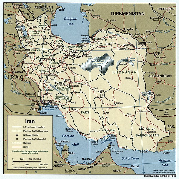
Iran.
United States. Central Intelligence Agency.
CREATED/PUBLISHED [Washington, D.C. : Central Intelligence Agency, 2001]
NOTES "802838AI (C00260) 10-01."
Scale [ca. 1:12,000,000] ; Lambert conformal conic proj., SP 26N/38N (E 440--E 640/N 400--N 240).
SUBJECTS Iran--Maps. Iran.
MEDIUM 1 map : col. ; 17 x 17 cm.
CALL NUMBER G7620 2001 .U5
REPOSITORY Library of Congress Geography and Map Division Washington, D.C. 20540-4650 USA
DIGITAL ID g7620 ct000939 http://hdl.loc.gov/loc.gmd/g7620.ct000939
| This image is a work of a Central Intelligence Agency employee, taken or made as part of that person's official duties. As a Work of the United States Government, this image or media is in the public domain in the United States.
|

|
Povijest datoteke
Kliknite na datum/vrijeme kako biste vidjeli datoteku kakva je tada bila.
| Datum/Vrijeme | Minijatura | Dimenzije | Suradnik | Komentar | |
|---|---|---|---|---|---|
| sadašnja | 21:27, 26. listopada 2005. | | 2.036 × 2.037 (1,84 MB) | Brian0918 | Iran. United States. Central Intelligence Agency. CREATED/PUBLISHED [Washington, D.C. : Central Intelligence Agency, 2001] NOTES "802838AI (C00260) 10-01." Scale [ca. 1:12,000,000] ; Lambert conformal conic proj., SP 26N/38N (E 440--E 640/N 400--N 240 |
Poveznice
Globalna uporaba datoteke
Sljedeći wikiji rabe ovu datoteku:
- Uporaba na ar.wikipedia.org
- Uporaba na bn.wikipedia.org
- Uporaba na ca.wikipedia.org
- Uporaba na en.wikipedia.org
- Uporaba na en.wikibooks.org
- Uporaba na fr.wikipedia.org
- Uporaba na gl.wikipedia.org
- Uporaba na he.wikipedia.org
- Uporaba na hy.wikipedia.org
- Uporaba na id.wikipedia.org
- Uporaba na it.wikipedia.org
- Uporaba na ko.wikipedia.org
- Uporaba na ms.wikipedia.org
- Uporaba na ru.wikipedia.org
- Uporaba na sh.wikipedia.org
- Šablon:Putevi u Iranu
- Put 71 (Iran)
- Put 11 (Iran)
- Put 12 (Iran)
- Put 14 (Iran)
- Put 16 (Iran)
- Put 99 (Iran)
- Put 22 (Iran)
- Put 15 (Iran)
- Put 17 (Iran)
- Put 18 (Iran)
- Put 19 (Iran)
- Put 21 (Iran)
- Put 23 (Iran)
- Put 24 (Iran)
- Put 26 (Iran)
- Put 27 (Iran)
- Put 31 (Iran)
- Put 32 (Iran)
- Put 33 (Iran)
- Put 35 (Iran)
- Put 36 (Iran)
- Put 37 (Iran)
- Put 38 (Iran)
- Put 39 (Iran)
Pogledajte globalnu uporabu ove datoteke.